Showing posts with label Kempegowda Tower. Show all posts

Thursday, June 26, 2014

The Eastern Frontiers - Kempegowda Towers

Having started off with the Kempegowda Tower that was closest to home (see earlier blog titled The North Western Frontier), I then had the occasion to be in the vicinity of the two towers that marked the eastern extremities of Bangalore as envisioned by its founder, Chieftain Kempegowda. I was carrying my DSLR in the first instance and had only my phone camera in the second.

TOWER # 2 :

First, the one that marked the North Eastern end - which is now on the banks of the Ulsoor Lake (in Central Bangalore !). This tower is not normally accessible as it is within Army territory (Madras Sappers). The best view of the tower, given the circumstances, is from the other side of the Ulsoor lake, close to the Tamil Sangam building on Annaswamy Mudaliar Road. Enter the Ulsoor Lake garden area through the gate diagonally opposite the Tamil Sangam building and you will catch  glimpse of the Kempegowda tower on U rock, through the bushes, behind the quirkily named Buffalo Ganj island.


The tower presents a very scenic sight, amongst flaming gulmohur trees, with the cool waters of the Ulsoor lake in the foreground. The tower, structurally, appears similar to the ones found at Sadashivnagar and Lalbagh, but seems to have lesser number of carvings on the gopura as compared to the one in Sadashivnagar.


Robert Hyde Colebrooke, a Lieutenant-Colonel in the Bengal Infantry, later to become Surveyor-General of Bengal (1794-1808), who was also a talented artist, apparently depicted one of the four Towers in a lithograph. I found this work of his on the web, depicting East Bangalore. Is it the original Kempegowda Tower or some other shrine ?


TOWER # 3 :

The South Eastern frontier was marked by the best known of the 4 Towers, on the granite rock in the 200+ acre Lalbagh. The rock itself is geologically significant as it is peninsular gneiss (amongst the oldest rocks on earth, about 3000 million years). This is what the Geological Survey of India site has to say about this rock formation : "The Lalbagh hill is composed of dark biolite gneiss of granitic to granodioritic composition containing streaks of biolite. Vestiges of older rocks are seen in the form of enclaves within the gneiss. Peninsular Gneiss of the region is dated 2500 to 3400 million years that accreted in three major episodes, i.e. 3.4 Ga, 3.3-3.2 Ga and 3.0-2.9 Ga. The quarries of Lalbagh are of great importance for researches on earth sciences towards evolution of the terrain"

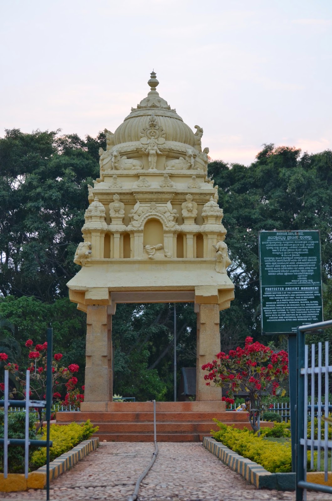
The tower is fenced off to prevent vandalism and the images of the gods on the gopura have been painted in bright colours, unlike in the case of the Sadashivnagar and Ulsoor Lake towers.

There is a stone etching inside the enclosure, explaining the significance of the tower, but the board is not easily readable.
The view from the top of the rock formation is a spectacular view of KH road and tall buildings like UB City beyond.

This tower is built at an altitude like the two others already described in this blog, and would have served its purpose as a watchtower as well. At one point in time, it should have been quite possible to see the three other towers from any of the 4 towers.

This leaves the tower near Kempambudhi lake as the fourth and last one to explore. That is an adventure for another day.

Tuesday, April 1, 2014

The North Western Frontier - Kempegowda Tower

The story of the four Kempegowda Towers that defined the boundaries of Bangalore has always fascinated me. The city having outgrown the boundaries defined then, I realize I now live beyond the North Western Tower that the visionary founder of the city placed in what is today called Sadashivnagar. 

Being the most accessible of the four towers (to me), I visited the park in which the tower is located, one evening last week. To get there, you have to go past Cauvery Theater on Bellary Road and head towards Mekhri Circle. Don't take the underpass but the road on the left which is beside the underpass. You will come across the Sri Ramana Maharshi Shrine & Meditation Hall and beside this building is the park where the NW Kempegowda Tower is located.
The main entrance to the Kempegowda Tower Park is on 11th main, which is a left turn from Bellary Road after the Sri Ramana Maharshi Shrine entrance. There is ample space available on this road for parking.

Alternately, you can use the entrance right next to the Ramana Maharshi shrine, especially if you have parked your vehicle in one of the earlier roads and are walking down Bellary Road.

It is quite a well-maintained park, with lots of trees and flowering shrubs. There is a stone plaque mentioning that the first sapling in the initiative to plant 1 lakh saplings in Bangalore was planted here by the then Chief Minister - Sr. S M Krishna, in 2002. The tower is deep-set inside the park, and although at an elevation - but is still not easily visible from the road.
 
The Tower itself has undecorated stone pillars but the gopura has sculpted images of gods and goddesses. Some of these images are broken and have head and torso missing. Fortunately, there is no sign of graffiti marring the tower.

On initial inspection, it seemed that the theme of the sculptures was Lord Shiva and family; but on perambulating to the other side, I spotted what was unmistakably a Krishna on the West side.
The park attracts a lot of birds. I distinctly saw a couple of koels and heard a few other birds. Another visit in the early morning hours is called for. I also noticed the customary fitness enthusiasts, but the park wasn't crowded at any point in time when I was there.

And then, in this pristine and sylvan environment, an ugly concrete structure caught my eye. A closer look and I was quite intrigued by the inscription on the embedded stone tablet. It proclaims that ‘The Bangalore longitude station of the Great Trigonometrical Survey was situated 38 feet north of the baseline station.’ The stone tablet credits Capt W M Campbell, RE, 1875 – 76 and Lt W J Heavyside RE 1887 – 88 with being ‘observers.’ When I got back home and googled "Great Trigonometrical Survey", Wikipedia had this to say - "The Great Trigonometric Survey was a project of the Survey of India throughout most of the 19th century. It was piloted in its initial stages by William Lambton, and later by George Everest. Among the many accomplishments of the Survey were the demarcation of the British territories in India and the measurement of the height of the Himalayan giants: Everest, K2, and Kanchenjunga. The Survey had an enormous scientific impact as well, being responsible for one of the first accurate measurements of a section of an arc of longitude, and for measurements of the geodesic anomaly." The page also had this interesting map produced by the survey. Quite fascinating, and I have downloaded a couple of reports on this survey and its impact for later reading.

 Source : http://en.wikipedia.org/wiki/Great_Trigonometric_Survey
So there is a little bit of British History and geology associated with this park as well. Here are some links to interesting related articles, in case you want to know more :

http://archive.deccanherald.com/deccanherald/feb152005/spt6.asp
http://thehindujobs.com/thehindu/2003/07/03/stories/2003070309370300.htm

I could not come away without visiting the Ramana Maharshi shrine, an oasis of peace in the middle of a traffic-busy road. The interiors are spacious and ideal for meditation.

I strongly recommend a visit to both the Kempegowda Tower Park and the Ramana Maharshi shrine - sanctuaries of peace in an otherwise bustling city.